
Mount Kenya: Peaks, Vegetation Zones and What the Name Means
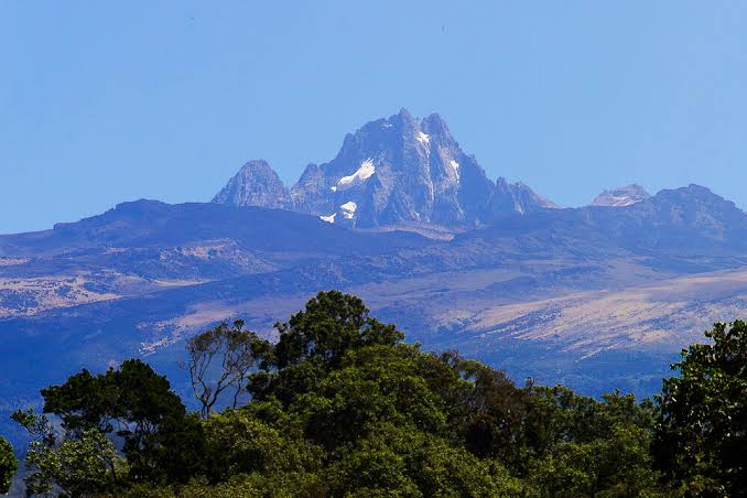
Mount Kenya is the second-highest mountain in Africa, an extinct volcano whose highest peak, Batian, stands at 5,199 metres. It lies about 150 km north-northeast of Nairobi, close to the equator, and is a UNESCO World Heritage Site. Its slopes pass through several distinct vegetation zones, from farmland and forest at the base to glaciers near the summit.
Quick take:
- Batian, the highest peak, is 5,199 m; neighbouring Nelion is 5,188 m
- Point Lenana, at 4,985 m, is the highest peak that can be reached without technical climbing
- Mount Kenya is an extinct stratovolcano, and its last eruption is dated to millions of years ago
- It became a national park in 1949 and a UNESCO World Heritage Site in 1997
- Its small glaciers have been shrinking
- Rhino Watch Safari Lodge, in Mweiga, Nyeri County, with views of Mt Kenya
How High Is Mount Kenya?
Mount Kenya has several peaks. Batian is the highest at 5,199 metres, and Nelion is only slightly lower at 5,188 metres. Point Lenana, at 4,985 metres, is the highest peak that can be reached without technical climbing, which is why it is the best-known objective for non-technical climbers.
The mountain is thought to have been much taller in the past. Ice cover has since eroded the peaks and slopes.
A Volcano That Is No Longer Active
Mount Kenya is an extinct stratovolcano. It formed after the opening of the East African Rift, and its last eruption is dated to roughly 2.6 to 3.1 million years ago, so there is no volcanic activity today.
Vegetation Zones From Base to Summit
Climbing Mount Kenya means passing through very different landscapes. From the base to the summit, the main zones are:
- Cultivated land and forest on the lower slopes
- A belt of African alpine bamboo
- Timberline forest
- Heathland and chaparral, from about 3,000 metres
- The Afro-alpine zone, with giant senecios and lobelias
- The nival zone, where glaciers have recently retreated and plants have not yet colonised
Protected Status
The area was gazetted as Mount Kenya National Park in 1949. It was designated a UNESCO Biosphere Reserve in 1978 and became a UNESCO World Heritage Site in 1997, recognised for its natural beauty and ecological significance.
What Does the Name Mean?
Local communities have their own names for the mountain. In Kikuyu it is Kĩrĩnyaga, which is described as meaning roughly “the one with the ostrich” or “white tails,” a reference to the snow and glaciers. In Meru it is Kirimaara, “mountain with white features,” and in Maasai it is Ol Donyo Keri, “mountain of stripes.” The name “Kenya” was given by the missionary Johann Krapf and later adopted by the country. Its exact derivation is not known with certainty.
Mount Kenya and the Central Highlands
The Mount Kenya massif spans several counties, including Nyeri. We are in Mweiga, Nyeri County, beneath Mt Kenya, near three wildlife reserves: Solio Game Reserve, Ol Pejeta Conservancy and Aberdare National Park. Guests mention the mountain in their reviews.
“An absolutely magical experience. Waking up to birdsong, the views of Mt Kenya at sunrise, and the warmth of the staff. We’ve already booked to return.”
— Sarah M., United Kingdom, TripAdvisor
“Aberdares NP is close to the property and has a totally different climate from the plains, well worth it for gorgeous scenery… The most amazing thing was the perfect view of Mount Kenya.”
— Andreas, United States, Booking.com
If you would like to plan time in the central highlands, you can check availability at Rhino Watch Safari Lodge.
Frequently Asked Questions
How high is Mount Kenya?
Its highest peak, Batian, is 5,199 metres. Nelion is 5,188 metres, and Point Lenana, the highest peak reachable without technical climbing, is 4,985 metres.
Is Mount Kenya a volcano?
Yes, it is an extinct stratovolcano. Its last eruption is dated to roughly 2.6 to 3.1 million years ago.
Is Mount Kenya a UNESCO World Heritage Site?
Yes. It became a UNESCO World Heritage Site in 1997, having been gazetted as a national park in 1949.
Where is Mount Kenya?
It lies about 150 km north-northeast of Nairobi, close to the equator. Its massif spans several counties, including Nyeri.
